Shemya photos, page 6
(Post-WWII)


1. This picture of Cobra Ball was supplied by Randy
Combs. Randy was on Shemya from March 1988 -
March 1989. (Randy Combs, March 1988-89)
2. This image of the Cobra Ball uniform patch was
supplied by Marty Gruber.
3. This is a close-up of Attu, North End, as taken from
Shemya near the Cobra Dane facility. (John Wolfe,
1994)
4. Aggatu, about 25 miles due south of Shemya, as
taken from the east end of the island at the Alascom
Earth Station. (John Wolfe, 1994)
5. From the east end of Shemya atop the 90 foot
tower at the Alascom Earth Station, a view of Shemya
in the immediate foreground with the Cobra Dane
facility to the extreme right. Nizki and Alaid Islands
are next in view (they are part of the Semichi Islands,
to which Shemya also belongs), then a wide view of
Attu in the far background. (John Wolfe, 1994)
6. The north side of Shemya as seen from the Cliff
House, an old "smokehouse" used for partying. There
is a cave up on the side of this hill. (John Wolfe, 1994)
7. Shemya's own missile launch facility that was part
of a now defunct project. Rumor has it the C-130
missed! Picture taken by USAF personnel on TDY
assignment to the island in 1997. (John Wolfe)
8. Taken from Bldg 600, looking south (more or less)
toward the "new" Communications Flight bldg. The
very edge of 600 is to the right, which is a stairwell.
Take that stairwell down, and it leads to a tunnel
under the street to the Comm building across the
street. Therein lies the telephone switch for the
island. The large building on the left is where the four
lane bowling alley was, and the old gymnasium. The
gym was used for teaching country line-dancing while
I was there, and our last combat dining-in. Picture
taken by USAF personnel on TDY assignment to the
island in 1997. (John Wolfe)
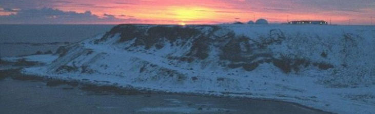
9. Shemya, Bldg 599, April 1994. (One of the best
snow-storms we had while I was on Shemya from
April 1975-1976 was in April of 1976! Smitty) (John
Wolfe) [John…Yup! I was trying to catch the
“Freedom Bird” off the island! Worried Snow would
prevent the trip!]
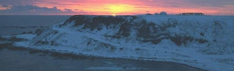
10. Shemya, Bldg 599 (front) is the bldg on the left,
with the backside of bldg 600 on the right. The small
structure next to the tower housed the two FM radio
stations for the island. February, 1995, during Phase II
weather. (John Wolfe)
![Bldg. 599, April 1994. Phase II Snowstorm Aftermath. [John Wolfe]](index_htm_files/81408.jpg)
![Cobra Ball, Shemya 1988-89. [Randy Combs]](index_htm_files/56540.jpg)
![Cobra Ball Uniform Patch. [Marty Gruber]](index_htm_files/56541.jpg)
![North End Of Attu, Taken 1994 From Shemya Near Cobra Dane. [John Wolfe]](index_htm_files/56542.jpg)
![Aggatu From East End Of Island, Alascom Earth Station. [John Wolfe]](index_htm_files/56543.jpg)
![Views Of Shemya From The East End, Showing Nizki & Alaid Islands With Attu In The Far Background. [John Wolfe]](index_htm_files/56544.jpg)
![Bldg. 599 Front During Phase II Weather. [John Wolfe]](index_htm_files/81414.jpg)
11. Shemya, Bldg 599 (front) during Phase II weather.
(John Wolfe)
12. Shemya Bldg. 599 During Phase II weather.
![North Side Of Shemya From The Cliff House. [John Wolfe]](index_htm_files/81415.jpg)
![Shemya's Own Missile Launch Facility. [John Wolfe]](index_htm_files/71153.jpg)
![Looking South From Bldg. 600. [John Wolfe]](index_htm_files/71154.jpg)
![Shemya, Bldg. 599 & 600. [John Wolfe]](index_htm_files/81418.jpg)
![Bldg. 599 During Phase II Weather. [John Wolfe]](index_htm_files/81419.jpg)
Current Update: 06/17/2022 14:44
Shemya photos, page 6
(Post-WWII)


1. This picture of Cobra Ball
was supplied by Randy
Combs. Randy was on
Shemya from March 1988 -
March 1989. (Randy Combs,
March 1988-89)
3. This is a close-up of Attu,
North End, as taken from
Shemya near the Cobra
Dane facility. (John Wolfe,
1994)
4. Aggatu, about 25 miles
due south of Shemya, as
taken from the east end of
the island at the Alascom
Earth Station. (John Wolfe,
1994)
5. From the east end of
Shemya atop the 90 foot
tower at the Alascom Earth
Station, a view of Shemya
in the immediate
foreground with the Cobra
Dane facility to the
extreme right. Nizki and
Alaid Islands are next in
view (they are part of the
Semichi Islands, to which
Shemya also belongs), then
a wide view of Attu in the
far background. (John
Wolfe, 1994)
6. The north side of Shemya
as seen from the Cliff
House, an old
"smokehouse" used for
partying. There is a cave up
on the side of this hill.
(John Wolfe, 1994)
7. Shemya's own missile
launch facility that was
part of a now defunct
project. Rumor has it the C-
130 missed! Picture taken
by USAF personnel on TDY
assignment to the island in
1997. (John Wolfe)
8. Taken from Bldg 600,
looking south (more or less)
toward the "new"
Communications Flight
bldg. The very edge of 600 is
to the right, which is a
stairwell. Take that
stairwell down, and it leads
to a tunnel under the
street to the Comm
building across the street.
Therein lies the telephone
switch for the island. The
large building on the left is
where the four lane
bowling alley was, and the
old gymnasium. The gym
was used for teaching
country line-dancing while I
was there, and our last
combat dining-in. Picture
taken by USAF personnel
on TDY assignment to the
island in 1997. (John Wolfe)
9. Shemya, Bldg 599, April
1994. (One of the best
snow-storms we had while I
was on Shemya from April
1975-1976 was in April of
1976! Smitty) (John Wolfe)
[John…Yup! I was trying to
catch the “Freedom Bird”
off the island! Worried
Snow would prevent the
trip!]
10. Shemya, Bldg 599 (front)
is the bldg on the left, with
the backside of bldg 600 on
the right. The small
structure next to the tower
housed the two FM radio
stations for the island.
February, 1995, during
Phase II weather. (John
Wolfe)
11. Shemya, Bldg 599 (front)
during Phase II weather.
(John Wolfe)
12. Shemya Bldg. 599
During Phase II weather.
Current Update: 06/17/2022 14:44