


LORAN
Originally Published: 12/02/2016


(LORSTA Attu, May, 1945.)
SECTION III
CHAPTER 2
The establishment of a three-station chain, plus a monitor station in the Bering
Sea, is a good example of the other side of the picture. The seven-unit system on
the Atlantic demonstrated the confusion resulting from "too many cooks in the
kitchen." While a certain amount of confusion is bound to result when attempting
the establishment of any station or outpost in the Bering Sea area, due to the
extreme climatic conditions, the speed and dispatch with which the first four
Alaskan units were put into operation is a tribute to the coordinated efforts of the
Coast Guard, the Navy and the Army.
It is perfectly obvious from the start why all three services would necessarily
participate in such a project. The U.S. Coast Guard was by this time possessed
of full responsibility for the operation and maintenance of all Loran units under
the jurisdiction of the United States. The Navy, however, was the prime user of
Loran at sea, and the service most interested in obtaining speedy service from it.
The Army had not only been in possession of the various points in the Alaskan
and Bering Sea Area which they had wrested from the Japanese, but had to
remain in some force in that area to maintain these outposts. Therefore the Army
would often be the neighbors of the U.S. Coast Guard units. Interference with
their communications systems already established had to be avoided at all costs.
In addition, the army already had near several sites, much of the heavy
construction equipment necessary in the construction of the units and by
borrowing this from the Army, the Navy and Coast Guard could avoid
transporting such equipment into the area, where transportation is a major
problem.
Practically all air transportation during construction was by courtesy of the Army.
In fact, the liaison between the various services was so excellent that within five
months from the issuance of the Navy directive, some of the units were on the
air. An excellent example of interservice cooperation will be found in excerpts
quoted from Lt. J. F. Martin's reports, later in this chapter.
As soon as the Navy directive calling for the establishment of the first three
Loran units in the Bering Sea area was received by the United States Coast
Guard activity began to assemble construction equipment, supplies, etc., in
Seattle for early shipment of the sites.
These first sites were located on St. Paul Island, St. Matthew Island, Umnak
Island, and a monitor to be established at Cape Sarichef. The code names given
these units in the order listed above were: peter, mike, uncle, yoke.
Since the locations for a number of the proposed Aleutian Station were in the
forward and remote areas, and also because of the unsatisfactory progress made
by the employment of civilian contractors for general construction work it was
necessary and obviously most practicable to organize a special construction
detachment to perform this work. A group was formed of selected enlisted men
and officer personnel who were qualified by their pursuits for the many types of
construction work required.
Five civil engineer officers were assigned by the Chief, Civil Engineering Division
for duty with CG Unit 26 (Condet Able) which was to undertake the construction
of the Aleutian and Bering Sea Chain of stations.
Lt. James Cournow, USCG, was placed in charge of procurement of all material
and equipment at Headquarters, under Capt. Gill and Admiral Johnson and Lt. J.
F. Martin, USCG, was designated as Commanding Officer, Coast Guard
construction Detachment and made his early operating base Seattle and later
Dutch Harbor.
Shipment of material equipment was begun in February 1943 to the West Coast.
Commanding Officers for construction and operations were selected and
departed for Seattle also in February.
Throughout the month of March and early April all cargo designated for the
projected units was assembled, checked and prepared for further shipment.
Much of the construction equipment and tools was obtained from the Seabee
advance base stock already in California. The Army contributed some special
foods and clothing that its logistic experts had already developed for life on the
northern islands.
On 12 April loading was begun and the liberty ship which carried the first cargo
of equipment, the USS JONATHAN HARRINGTON, with about 100 Coast Guard
construction and technical personnel on board, sailed shortly thereafter.
According to the account given by Lt. J. G. Permar, Civil Engineering Div., USCG,
who sailed with her in charge of construction for Mike, they had an eventful trip.
En route to Kodiak, the vessel had a submarine alert, which after all hands
standing battle stations turned out to be a whale. The ship stopped at Kodiak to
unload some cargo and the Coast Guard personnel had two days liberty ashore
there. Then on Easter Sunday, 25 April the reached Dutch Harbor, where
unloading began at once. The unloading was concluded within two days.
The CGC CLOVER had been assigned to assist in transporting the cargo on the
sites and the cargo was transshipped onto her with all speed. Then bad weather
set in and the CLOVER did not sail until early May.
Expediency has its virtues as shown in the following excerpt from Lt. Martin’s
report of 19 May 1943:
"On 16 May the cutter CLOVER sailed for site P-3 (Mike.) At this time she was
towing the small tank landing barge (borrowed.) When about 12 miles at sea the
barge was capsized owing the excessive towing speed, which was ten knots.
Efforts were made to right the barge at sea, but owing to conditions (climatic),
this could not be done, and upon orders of the writer it was towed back into the
harbor and beached. With the use of a large tractor it was righted and work was
commenced immediately to tear down and clean the engines. This work is
progressing favorably and it is estimated the barge will again be ready for use
about 24 May.
"With the idea of getting work started, the CLOVER was ordered to sail for site P-
1 (Peter) which she did at 0900 17 May. She arrived there at 1023 18 May and
work of unloading was started immediately. A dispatch has just been received
stating that his work was completed, and she is returning for the second and
final load of supplies. With the assistance of the Army detachment on the island
a road has been started from the landing along the bluff on south side of island
to site. There are about 300 men (Army) with considerable mechanical equipment
in this detachment and full cooperation is being given. Coast Guard construction
personnel to the number of thirty were taken on the first trip and these men are
remaining on the job under the direction Ensigns Permar and O'Meara."
Thus it happened that Ensigns Permar and O'Meara who were originally destined
to handle construction on St. Matthew, ended up by building the unit on St. Paul
instead with a saving of time and effort on the part of all concerned.
The cooperation of the Army detachment mentioned above is also representative
of all the detachments stationed anywhere near Loran sites in the entire area.
Ens. Permar stated that another reason for diverting the original construction
unit from Mike to Peter was that following the capsizing of the barge; a wire was
sent the Army at St. Paul requesting the use of a lighter. The Army replied that
they could supply one for unloading there and with the aid of the Army the
CLOVER was unloaded within twenty-four hours after arrival at Peter. The
unloading point on this island was near a native village, which had just returned
to their homes in the village a few days before the arrival of the CLOVER. They
seemed very glad to see the Coast Guard arrive greeting them as old friends and
expressing pleasure that a station would be on their island.
The materials at Peter were trucked for five miles over a road, then moved the
last three miles to the site in borrowed Army tractors and track type trailers. The
construction camp was set up at the three-mile point where the Coast Guard
personnel lived in tents, using an abandoned fox trapper's shack as galley.
All land for the first three sites had to be obtained from the Secretary of the
Interior, by the Secretary of the Navy, as the sites were situated on either grazing
rights or wildlife sanctuaries. Silver and blue fox, reindeer, and Kodiak bear
populated the island and one unit required telephone repairs rather often as the
reindeer persisted in knocking down the wires with their antlers. The use of the
sites by the Coast Guard was granted for the duration and six months thereafter.
The construction and installation of this particular unit proceeded with no undue
hardship on the part of the Coast Guard crew. The main difficulty was
encountered by the CLOVER, which found it difficult at time to maintain regular
unloading schedules at all the sites as the weather was always so uncertain in
that region that of ten she had to stand off for fog, and Peter, Uncle, and Yoke
had their share also. Within ten minutes so variable was the weather; the same
spot would experience bright sunshine, rain, then snow, and then fog.
It seems unnecessary to cover in detail the construction of each separate site in
this chain as construction proceeded almost simultaneously at all four points,
and difficulties encountered at one would probably be duplicated at some time at
all of them.
It was necessary at all four of the sites to remove the layer of muskeg before
building, as the muskeg was so spongy that no permanent erection could be
anchored to it. This was done with heavy Army "cats" and tractors. Special
precautions had to be taken in the erection of the antennae, as the winds there
are forceful and special guying was advisable. Often in the water supply proved a
problem, which in some cases was overcome by chlorination of the local supply
or in others by the use of evaporating units.
Unlike the situation of the men constructing the original Atlantic Loran system,
the Coast Guard personnel in the North Pacific area suffered no shortage of food,
medical supplies, necessary construction supplies, etc., due to the excellent
combined logistics of the various Services participating in the program. Their
buildings were weather tight, their clothing was correct and adequate; they did
not have to await the pleasure of civilian contractors for the installation of their
plumbing, and health and morale were reported as uniformly good. On 4 July
1943 the Coast Guard crew stationed at Peter played the Army construction outfit
at softball. Army won.
It is a tribute to excellent personnel work on the part of both the Army and Coast
Guard officers stationed on these islands that the personnel maintained such
harmonious relations, especially since the Coast Guard mess equipment and
sometimes pay exceeded that of the Army.
While the Army, as has been shown, gave all possible construction aid, more
difficulty was encountered on some of the other islands in landing supplies and
equipment than at St. Paul. In some cases, the harborage was nil, in other
williwaw conditions prevailed and in others the site was extremely difficult to
reach from the landing point. However, all things considered there was a
minimum of friction delay and discomfort.
Credit should be given the Commanding Officers and Construction Officers of
the U. S. Coast Guard who drew this first all-service assignment for their tact,
resourcefulness, and efficiency.
The original officers for the first three units established and the monitor were as
follows:
St Paul - "Peter"
Construction - Ens. Permar
Commanding Officer - Ens Albert J. Preston
St. Matthew - "Mike"
Construction - Lt. (jg) Horder
Commanding Officer - Ens. Barwick
Umnak - "Uncle"
Construction - Ens, J. J. O'Meara
Commanding Officer - Ens. Drouin
Cape Sarichef - "Yoke"
Construction & Commanding Officer - Guy Bellinger, CRM
During the construction period, all personnel were under the jurisdiction of the
Officer in Charge of Construction Detachment, USCG, Lt. Martin at Dutch Harbor,
Alaska. When test operations began the operating officers and crews came under
the jurisdiction of Lt. Comdr. Amos, USCG.
It should be noted here, though without undue emphasis that the original
Commanding Officer of Uncle was considered unqualified, before construction
began, by Lt. Martin and Headquarters was so informed. He was shortly replaced
for this duty by Ens. Drauin who carried out the major part of the installation of
technical equipment and put the unit on the air. Mention is made of this situation
only for the reason that it emphasizes the necessity for careful selection
Personnel for all such specialized assignments as much time and effort can be
lost when such care is neglected at the start.
Ens. O'Meara did not remain long at Peter, but proceeded to Umnak as soon as
weather permitted and carried out construction operations there. By July 15 1943
Peter was ready to go on the air test and Ens. Permar departed on that date on
the CLOVER to Dutch Harbor. Here he picked up a load for Uncle and upon
reaching there remained supervising construction for about a month until the
unit was ready to go on the air.
With the order to construct these units, the decision was also reached by the
Navy to relieve NDRC of the onus of equipment production. This was effected
early in 1943 and technical equipment thereafter for all Loran units was obtained
through BUSHIPS. With this move, the last connection between NDRC and the
establishment of Loran units was beginning to be severed as Mr. Fletcher Watson
formerly Secretary for NDRC and an accomplished astronomer, accepted a
commission in the U.S. Navy and as Lt. Watson of Hydrographic covered the
charting job.
It is of interest to note so poorly had the Bering Sea Islands been shown on all
available charts, that when the Loran Units went on the air testing there true fixes
proved the location of the various islands on existing charts to be as much as
several miles in some cases, out of position. For that reason Hydrographic
Office, USN has found it necessary to Loran re-chart practically the entire area.
In July, 1943 a site survey party covered the Aleutian Islands and selected sites
for three more units of Loran at Amchitka, Attu and Adak, as Dutch Harbor was
considered too far away for efficient correlation of activity.
It is not good historic practice to record the good and omit the bad when giving a
true record and therefore it must be admitted that although conditions and
delays were much worse in the Atlantic chain, the Pacific chains were costly in
loss of life. Although Mike had been listed as expendable it was not believed that
any of the losses of personnel in the Pacific area were due to enemy action
though there is some doubt in one case.
During the testing period of the units, five enlisted men were lost. Mystery still
enshrouds the loss of these men who set out from Mike in a small boat for a
shoreline trip to an Army weather stations some nine miles away. Ensign E.T.
Barwick, USCG, C.O. at Mike reports as follows:
"At 1500, 20 September 1943 boat crew consisting of HAGLUND, Floyd O. (220-
806) RM1c, BREIMO, Elmer O. (538-953) Cox. (r), HAGEN, Edward C. (584-147)
RM3, SCHMOLL, Kenneth H. (506-786) RM3 (r), and MACLAND, Thomas L. (636-
878) Sea. 1c (r), departed from this station.....the boat crew's orders were to pick
up a small gasoline engine generator formerly used by Army weatherman in
transmitting weather reports to St. Paul Army Garrison."
The men, boat, and all equipment in the boat disappeared without a trace.
Searching parties were sent out along the shore to the destination of the boat's
crew and search was also made along the beach and by boat. At 1338, 24
September, a PBY dispatched from Adak joined the search but to no avail. Two
other paragraphs from Ens. Barwick's report may or may not be significant.
However they are worth quoting in absences of any conclusion proof of the exact
fate of the men:
"There is slight evidence that the members of the boat crew might have met with
enemy action been taken prisoners." And...."As yet there is no evidence such as
floating oars, lifejackets, pieces of wearing apparel or boat having washed
ashore."
"YP 197 advised at 1400, 28 September 1943 there their searching party had
found a 5-gallon oil can floating between Pinnacle Rick and this unit, which was
later identified as fuel can used in surf boat in which boat crew departed." Also
strange human footprints were found at this time on this uninhabited island.
In addition, these paragraphs to make the mystery more complete:
"In making trip to the Army site via water it is unnecessary to navigate more than
200 yards off shore at any time and men were under orders to keep within this
limit, as the writer made the trip several times with Haglund and Breimo
instructing them which course to pursue."
"At the time the boat crew departed, the sea was calm and no difficulties were
encountered when launching boat through the surf."
Unlike earlier Loran construction parties, ConDet "A" arrived at the Western end
of the Aleutian Islands during the latter part of 1943 with an outfit that the
Japanese may have had in mind when they complained of the "Unsportsmanlike
conduct of the war by way of vulgar display of wealth." However, the job was
being undertaken at the worst time of year in order to make Loran in dire need of
such service in the western Aleutians.
This auspicious beginning, however was literally "the calm before" so many
storms that the Aleutian construction detachment began to think they had been
assigned to "Hell's Corner".
Men and materials began to arrive at sites 62 (Adak) [sic], 63 (Amchitka) and 64
(Attu), beginning in early November 1943. Liberty ships and the Coast Guard
cutter CITRUS did the transporting. The Liberty ship GEORGE FLAVEL left
Seattle 24 October and arrived at Adak 18 November. The Liberty ship McKENZIE
with material and some personnel aboard arrived at Attu on 3 December after
stopping at Adak and Amchitka on the way.
Since the Aleutian Islands are conceded to produce some of the world's worst
weather and since the coastline in that area consists mainly of mountainous
jagged rocks standing on end, swept by violent tides, currents and monumental
surf all landings were "by the grace of god" and extremely hazardous and
precarious. Attu undoubtedly presented the largest and most varied collection of
climatic and physical difficulties of the three Aleutian sites, so that a detailed
description of the construction there will encompass all hazards encountered in
the entire Aleutian operation.
According to Lt. Comdr. Russel Yates, USCG, C.O. ConDet "A" the lack of
warehouse space and spare huts on Attu on arrival was acute. The Coast Guard
construction crew was immediately forced to erect three Quonset huts for
storage space at Massacre Bay, with material furnished by the Sea Bees there.
Then the first section of the construction party left for site 62. They established a
temporary construction base camp at Baxter Cove, since the site survey party
had selected this spot as the only place anywhere near #62 where landing might
be possible.
Wooden barges brought to Attu, to be used in unloading operations "were found
unsuitable for this location", a mild way of stating that they were smashed to
matchsticks on the rocks in the surf. Those left were traded for a 5x7 steel
pontoon type barge with removable sections, which is being extensively used by
all armed forces in landing operations. These pontoon barges, or "Admiral
Laycock's cigar-boxes", are the only type of equipment which can withstand
such a shoreline, since two-thirds of the section can be punctured on rocks and
they will still retain their buoyancy.
Tents, mess hut and Loran transmitting equipment storage hut were erected
during the usual foul weather and the ubiquitous "Cat" was started on the
construction of the two and half mile road to the site.
Lt. Cmdr. Yates gave the high points of this killing two and a half miles in a few
succinct paragraphs when he said:
"The first five hundred feet of the road took us through an Aleutian cemetery
located under a dummy gun emplacement that the Japs had abandoned a few
months before. Desecrating an Aleut grave is a serious offense, but we were
unaware of it until we started turning up human skulls and bones of prehistoric
animals which had been in turn, buried deep below ivory trinkets and tons of bird
and fish bones."
"Another midway tent was erected a mile and half from Baxter Cove to serve as a
mess hut and shelter during round the clock work on the road."
"After consultation with the aerologer, it was decided to unload a large portion of
the building materials on 24 December. And other 5x7 steel pontoon barge was
borrowed from the CB's and in company of the CITRUS, both barges arrived off
Baxter Cove shortly after noon of that day. A heavy ground swell made unloading
from the cutter to the barge precarious and the unloading was further delayed by
increasing swells and a weather report that a sudden squall was headed our
way."
In spite of conditions becoming rapidly adverse, both barges made the beach
about sundown and temporary floodlights were rigged. Unloading operations
continues all Christmas Eve and until noon on Christmas Day. By then, heavy
seas were tossing the barges around on the rocks men were escaping death by a
hair every other minute in an effort to complete the unloading and the confusion
that existed was like 'midshipmen on watch.'
"The storm increased in intensity and the CITRUS was unable to maintain her
anchorage, (there is very little good anchoring bottom in the Aleutian area), and
was forced to return to Massacre Bay for shelter. All hands ashore, which
included some of the CITRUS' crew, remained there until the storm subsided, 2
January."
Most of the materials were carried to the site from Baxter Cove on a barge sled,
made by the crew and pulled by the "Cat". The road was formally christened
Hooligan Highway and when completed was quite one of the engineering
wonders of Attu.
The antenna poles were rafted and towed to Baxter Cove, then hauled over
Hooligan Highway by the "cat" to the site. Because of the sharp turns in the road,
a switchback donkey winch had to be employed. Throughout all operations
winds sometimes reaching velocity of 125mph raged and snow twelve feet in
depth paralyzed vehicular traffic for days. Only the power line survived the
storms and the days were filled with the struggle to push construction and at the
same time repair constant storm and wind ravages.
Site 62 was out of touch with Massacre Bay for five days in early February.
During that time the crew erected several 90' antenna poles in ideal calm
weather. It was later learned that the Massacre Bay area only fifteen miles away
had been swept by a five day storm with 125mph winds. Mail had to be dropped
at the site from a plane as landings at site could only be made during the best of
weather, which was so seldom it would furnish food for conversation for days
afterwards.
The armed services paid dearly in loss of lives for tenure of the Aleutian Island.
In the same storm which struck Massacre Bay, nine men were lost on an ATS tug
which went down only two hundred feet from the Army dock with the help unable
to reach them from the shore. In all the Army lost approximately fifty men during
January and February of 1944 in landslides and to the sea.
At Attu, the Coast Guard was frequently called upon by the Navy COP to assist in
rescues and salvage work. The CITRUS took nine men off a swamped ATS tug
without loss of life and then sank the dying tug with gunfire. She also assisted in
getting the Liberty ship off the beach where it had been driven in a severe storm.
The members of the Coast Guard construction crew at site 62 removed nine more
Army men from a battered ATS power barge and received a commendation for
their gallantry from the Commanding General of the Area. Such rescue and
salvage work could have become an all-time job for the personnel for the Coast
Guard in the vicinity, if they could have spared the time from their regular duties
as in addition to the fiendish weather, the harbor at Attu was very poor with little
shelter and a bad "holding" bottom.
Site 62 was located on a saddle of the hills, at an elevation of twelve hundred
feet. It required the use of bulldozers to reach it with materials and the
employment of switch backs due to the terrain and steepness of the slopes.
William A. Baughman, Sea. 1c was killed on the stitch back when the "cat"
slipped out of gear and rolled over him on its steep descent to the edge of the
bluff.
The Coast Guard paid for Aleutian Chain with other lives too. Ensign Johnson,
C.O. of unit 64 was killed when the PBY he was in crashed making a landing in
Dutch Harbor. He was engaged in running baselines when it happened. Another
plane a Coast Guard PBY with its entire crew was lost without trace, near Point
Heiden, while returning to the States.
With all these misfortunes and all nature leagued against them the Construction
crews in the Aleutians did a magnificent job and in an amazingly short time.
Three months after the landing at Baxter Cove the construction crew were
gradually beginning to be returned to the states. The last man left the Aleutians
about 15 March 1944 and the regular operational crews took over. After extensive
testing operations all three stations were commissioned 18 May 1944 and turned
over to the jurisdiction of the Aleutian Representative at Adak, Lt. Bob Kersten.
The great significance of the construction feat in the Aleutians lies obviously in
the fact that in spite of the most adverse conditions the Coast Guard working
with the cooperation of the other armed services can erect short lengths of time.
A tribute indeed to splendid organization and the staunch determination of the
personnel engaged worthy of the tradition of the United States Coast Guard at its
best.


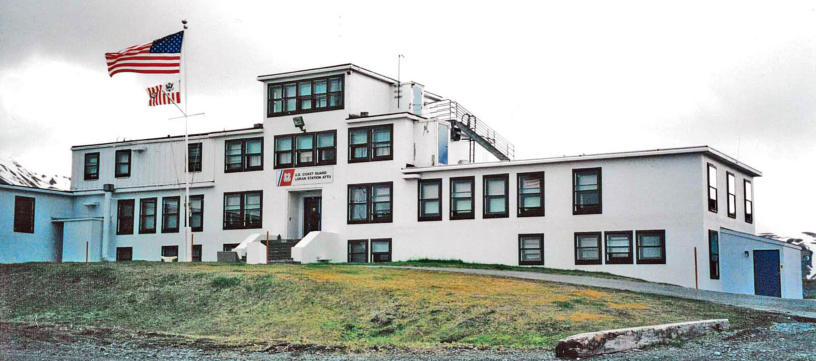
Photo by Russ Marvin


![LORAN-A Station at Murder Point, Attu, 2000. [Russ Marvin]](index_htm_files/267634.jpg)
#4. LORAN-A Station, Murder Point; established in Nov
1948, abandoned in Jul 1961 for newer quarters and
location which became the current LORAN-C Station at
Cosco Cove near Massacre Bay. These abandoned
buildings were used by the now defunct “Attours, Inc.” to
house tourists on birding trips to Attu Island. (Russ
Marvin)
Coordinates: 52°48'17.10"N x 173° 9'46.28"E![LORAN STATION-A, Murder Point. [Google Earth]](index_htm_files/263301.png)
#5. Aerial View; LORAN STATION-A, Murder Point. These
buildings were put to use by Attours, Inc. to house their
Birding Tour participants after the new LORAN-C station
was built. Attu’s runway can be seen directly above, on
the other side of Casco Cove. The newer LORAN
STATION-C station is located on the right side of the
runway, near the top of the photo. (Google Earth)
Coordinates: 52°48'17.10"N x 173° 9'46.28"E![2000; Attu's LORAN-C building at Casco Cover near Massacre Bay. [Russ Marvin]](index_htm_files/267636.jpg)
#6. 2000; Attu’s LORAN-C building at Casco Cove near
Massacre Bay. Established 10 Jul 1961, closed 26 Aug
2010. (Russ Marvin)
Coordinates: 52°48'17.10"N x 173° 9'46.28"E![2000; Location of newer LORAN-C buildings and antennas at Casco Cove near Massacre Bay. [Google Earth]](index_htm_files/263303.png)
#7. Location of newer LORAN-C buildings and antennas
at Casco Cove near Massacre Bay. Closed August 2010.
Coordinates: 52°48'17.10"N x 173° 9'46.28"E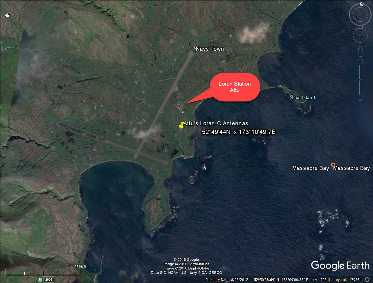
Updated: 12/08/2016 07:24


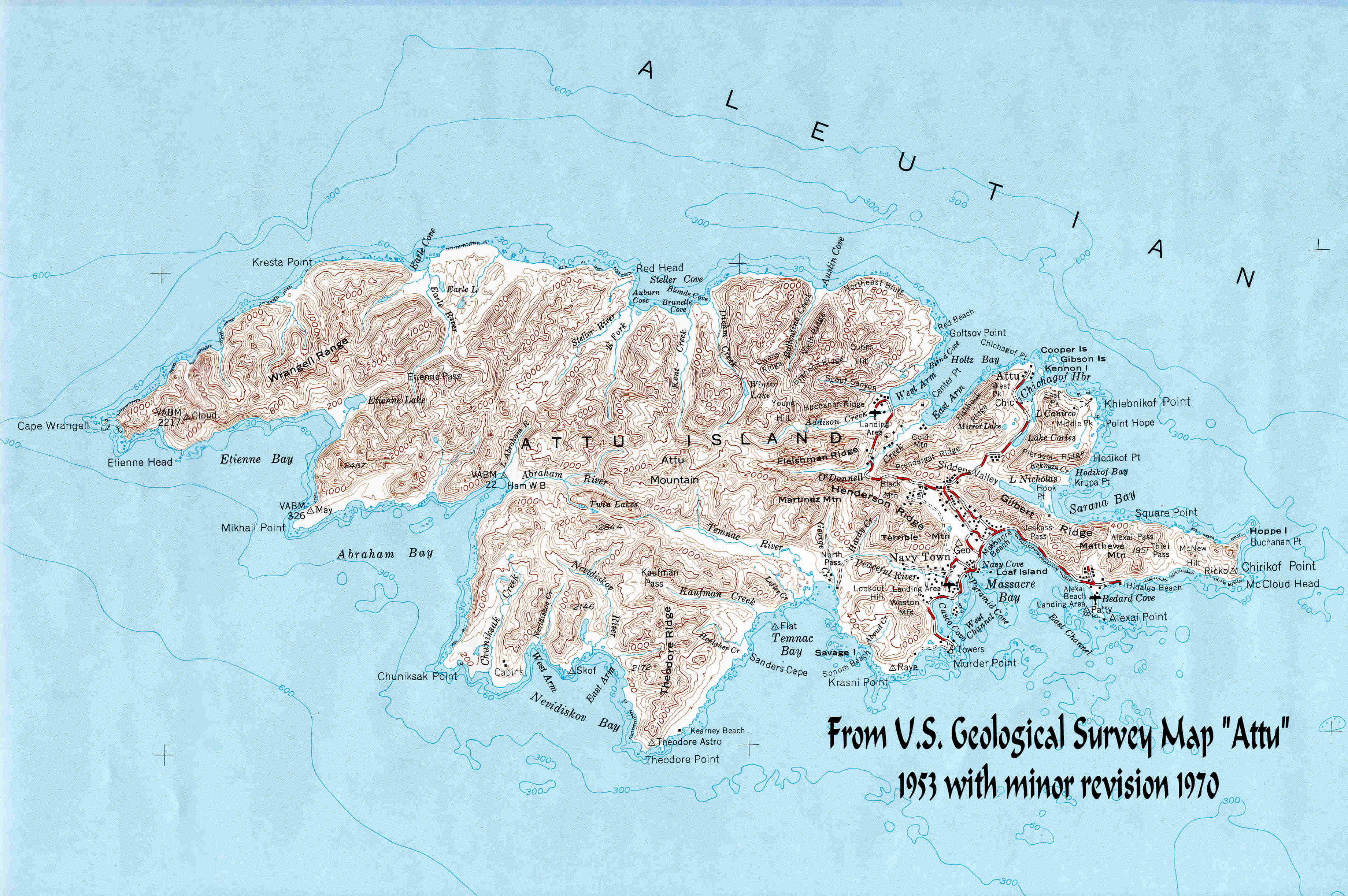
![The original LORAN-A station established at Theodore Point, Attu, on September, 1943. Operational 1944 - 22 Jun 1949. [NARA]](index_htm_files/267638.jpg)
#1. 1944-1949; LORAN-A Station, Theodore Point. (NARA)
The original LORAN-A station established on Attu on September, 1943. Operational 1944 - 22 Jun 1949. Coordinates: 52°45'09"N x 172°54'31"E Sourced From: Loran-History![1944-1949: Original LORAN-A Station on Attu's Theodore Point. [Google Earth]](index_htm_files/263305.png)
#2. 1944-1949; LORAN-A Station, Theodore Point.
(Google Earth)
Coordinates: 52°45'09"N x 172°54'31"E
Sourced From: Loran-History
“The first of Attu’s LORAN-A stations was initially located at Theodore Point before being
moved to Murder Point. Then came the new LORAN-C site which was located at Massacre Bay
where the current station buildings are located.
In May 1942, the CNO requested a Coast Guard Officer having electronic engineering
experience be assigned to him. That was LCDR Harding. Harding's job was the liaison with MIT
RADLAB which was the LORAN Project. Harding coined the term LORAN. The Coast Guard ran
the LORAN system since its inception. On 25 March 1959, the MEDSEA LORAN-C chain was
declared operational. In true Coast Guard fashion, the CG and the LORAN system served the
general public as well as the USN and others in the DOD.
The MEDSEA stations were turned over to host nations in the early 1990s. By the end of 1994
they stopped transmitting. The Coast Guard’s affiliation with LORAN ran from May 1942 to
August 2010 when transmissions were terminated…which consequently also terminated Attu’s
role as part of the Eastern Russian NAVAIDS Chain.
There were LORAN signal transmissions emanating from Theodore Point beginning 11
February 1944 until 1 August 2010 when transmissions ceased from the current Massacre Bay
location. Sixty six of the sixty eight years of United States involvement with LORAN, Attu
stands tall as having provided the longest active period of LORAN transmissions.”
Ardon Smith
Theodore Point, WWII


From Wikipedia:
“LORAN, short for long range navigation, was a hyperbolic radio navigation system developed
in the United States during World War II. It was similar to the UK's Gee system but operated at
lower frequencies in order to provide improved range up to 1,500 miles (2,400 km) with
accuracy of tens of miles. It was first used for ship convoys crossing the Atlantic Ocean, and
then by long-range patrol aircraft, but found its main use on the ships and aircraft operating in
the Pacific theatre.
LORAN, in its original form, was an expensive system to implement, requiring a cathode ray
tube (CRT) display. This limited use to the military and large commercial users. Use was never
widespread, and by the time new receivers were available in the 1950s, the same improved
electronics led to new systems with higher accuracy. The US Navy began development of
Loran-B, which offered accuracy on the order of a few tens of feet, but ran into significant
technical problems. The US Air Force had worked on a different concept, known as Cyclan,
which the Navy took over as Loran-C. Loran-C offered longer range than LORAN and accuracy
of hundreds of feet. The US Coast Guard took over operations of both systems in 1958.”
“The original LORAN was proposed by Alfred Lee Loomis at a meeting of the Microwave
Committee. The US Army Air Corps was interested in the concept for aircraft navigation, and
after some discussion they returned a requirement for a system offering accuracy of about 1
mile (1.6 km) at a range of 200 miles (320 km), and a maximum range as great as 500 miles
(800 km) for high-flying aircraft. The Microwave Committee, by this time organized into what
would become the Radiation Laboratory, took up development as Project 3. During the initial
meetings a member of the UK liaison team, Taffy Bowen, mentioned that he was aware the
British were also working on a similar concept, but had no information on its performance.
The development team, led by Loomis, made rapid progress on the transmitter design and
tested several systems during 1940 before settling on a 3 MHz design. Extensive signal-
strength measurements were made by mounting a conventional radio receiver in a station
wagon and driving around the eastern states. However, the custom receiver design and its
associated cathode ray tube displays proved to be a bigger problem. In spite of several efforts
to design around the problem, instability in the display prevented accurate timing
measurements.
By this time the team had become much more familiar with the British Gee system, and were
aware of their work on "strobes", a time base generator that produced well-positioned "pips"
on the display that could be used for accurate measurement. They met with the Gee team in
1941, and immediately adopted this solution. They also found that Project 3 and Gee called for
almost identical systems, with similar performance, range and accuracy. But Gee had already
completed basic development and was entering into initial production, making Project 3
superfluous.
In response, the Project 3 team told the Army Air Force to adopt Gee, and realigned their own
efforts to provide long-range navigation on the oceans. This led to US Navy interest, and a
series of experiments quickly demonstrated that systems using the basic Gee concept but
operating at a much lower frequency around 2 MHz would offer reasonable accuracy on the
order of a few miles over distances on the order of 1,250 miles (2,010 km), at least at night
when signals of this frequency range were able to skip off the ionosphere. Rapid development
followed, and a system covering the western Atlantic was operational in 1943. Additional
stations followed, covering the European side, and then a massive expansion in the Pacific.
By the end of the war there were 72 operational LORAN stations, and as many as 75,000
receivers.
In 1958 the operation of the LORAN system was handed over to the US Coast Guard, which
renamed the system "Loran-A", the lower-case name being introduced at that time.”
While researching information pertaining to LORAN station history and technical data I was
fortunate enough to have discovered on the United States Coast Guard’s website:
http://www.uscg.mil/history/STATIONS/LORAN/docs/LORAN_Section_1.asp From this site I was able to extract an abundance of historical facts relating to the development of LORAN, as well as the establishment of the LORAN station on Attu: LORSTA ATTU. The following information has been extracted from that document:![Google Earth Location of Theodore Point's LORAN Station Location. [Joe Jester]](index_htm_files/263306.png)
#3. Google Earth image of Theodore Point’s LORAN
Station location. (Joe Jester)
