Photo By Kare Lohse
PHOTOS: ATTU, WWII - PAGE 2
“Miscellaneous Photos From Various Sources”


Photos extracted from “The Capture of Attu,” contributions from George & Nadine Smith, Nick Moreska, Walter H.
Knight, and from numerous eBay purchases. Click on each photo thumbnail to see a larger rendition. If anyone can
identify the photographer for any individual photos, or can identify any of the unidentified folks in these pictures,
please eMail the info to me! Thanks! Click on the Grid Map to view it as a larger image. As photos are added to this
page, I'll attempt to add location coordinates that reference this map.
![Clevesy Pass, northeast side of upper Massacre Valley. [The Capture of Attu]](index_htm_files/221135.jpg)
1. From "The Capture of Attu," Page 110 and 111 bottom photo text: "Clevesy
Pass, on the northeast side of upper Massacre Valley; led across to Sarana Valley
and the distant heights of Prendergast and Fish Hook ridges. Strong Jap
trenches, machine-gun and mortar emplacements held the slopes of Cold
Mountain and the ridge leading up to Point A (Point Able). Deadly fire swept the
exposed slopes leading up to the pass. On May 19 the 2d Battalion of the 17th
Infantry, and the 2d Battalion of the 32d Infantry, successfully assaulted these
positions and opened the gate for a drive against Sarana Valley and the
Chichagof heights."
![Colonel Wayne C. Zimmerman directing the Southern Force's attack against Clevesy Pass, 19 May 1943. [The Capture of Attu]](index_htm_files/221136.jpg)
2. Colonel Wayne C. Zimmerman (now Brigadier General), commander of the
Southern Force, and Lieutenant Winfield H. Mapes, 17th Infantry, in an OP on
the north slope of the Hogback. Colonel Zimmerman is directing the Southern
Force's attack against Clevesy Pass on May 19th, 1943. (From "The Capture of
Attu")
![The first heavy-duty highway from Blue Beach, Massacre Bay...a gravelly stream bed! [The Capture of Attu]](index_htm_files/221137.jpg)
3. The first heavy-duty highway from Blue Beach, Massacre Bay. Tractors which
often bogged down in the tundra used this gravelly stream bed entirely during
the first week and partially thereafter. This "cat" with trailer is coming
downstream empty for another load. To the men on the front lines flowed a real
stream of supplies. (From "The Capture of Attu")
![Manpower moved most of the front-line supplies and ammunition. [The Capture of Attu]](index_htm_files/221138.jpg)
4. Manpower moved most of the front-line supplies and ammunition. Tractors
were few on Attu and vulnerable to Jap fire. Here men of the 4th Infantry haul
mortar ammunition and combat equipment up the Hogback. (From "The
Capture of Attu")
![First Jap defenses on Attu fall: troops gather around a field stove, Holtz Bay area, for a hot breakfast, 29 May 1943. [Navy Photo]](index_htm_files/264528.jpg)
5. 5/29/1943: First Jap Defenses on Attu Fall: Good humor was apparent as
American fighting men gathered around a field stove in the gray mist of
morning at a point in the Holtz Bay area of Attu to get a hot breakfast. Note
shell pocks in the plain to the rear. This is one of the first pictures of American
occupation of the outer ring of Jap defenses on Attu. Credit: (Official Navy Photo
- ACME) (WS) Click HERE for photo’s reverse side. [Provided by Nadine Smith,
Posted by George L. Smith]
![On of Attu's newly constructed docs, Massacre Bay. [George & Nadine Smith]](index_htm_files/264529.jpg)
7. One of the newly constructed docks located at Attu's Massacre Bay.
!["Navy Town," Massacre Bay, Attu Island, AK, 27 July 1943. {George & Nadine Smith]](index_htm_files/264530.jpg)
8. Navy Town, Massacre Bay, Attu Island. In the foreground you can see supplies
protected under tarpaulins. The temporary mess hall and living quarters are
located in the center. 27 July 1943. Click HERE for enlarged view.

9. This airfield was built on Alexei Point (Coord J5) after the capture of Attu, and
shows some of the P-38s sitting on Perforated Steel Plating (Marsden Matting).
Contributed by George Smith from b&w slide found on Shemya in 1975.
![July, 1943. Commemorating location where Col. Yamasaki met his death executing his final Banzai attack against American defenders. [Nick Moreska]](index_htm_files/221143.jpg)
10. This photo was taken in July, 1943. It commemorates the location where the
Commander of the Japanese Force on Attu, Col. Yasugo Yamasaki, met his death
while executing his final Banzai attack against the American defenders. The
location is at H-3 on the Attu grid map, after you pass Engineer Hill (the Colonel's
last stand) and over Buffalo Ridge to Holtz Bay. Click HERE for the sign’s text.
[Nick Moreska]
![P-38 and crew, Alexai Point, Attu, AK. Notice the Perforated Steel Plating (PSP) runway! [George L. Smith]](index_htm_files/264533.jpg)
11. This picture of a P-38 with crew was taken on Attu. Notice the Perforated
Steel Plating (PSP), aka Marsden Matting, runway. This landing strip was located
on Alexi Point (Coord J5). The mountain in the background is Mt. Terrible (or
"Gobler's Knob" as it was known to the GI's of the day). Contributed by George
Smith who extracted the image from b&w glass slide found on Shemya while
working the photo hobby shop in 1975.
![P-38 Buzzing the airfield, either Attu or Shemya. [George L. Smith]](index_htm_files/221145.jpg)
12. This picture could have been taken on either Attu or Shemya. It is, as the
inscription indicates, a P-38 buzzing the area. Contributed by George Smith who
extracted the image from b&w glass slide found on Shemya while working the
photo hobby shop in 1975
![Nick Moreska, fall of 1944, with the 7th Div 159th Inf. Regiment, in front of his hut. [Nick Moreska]](index_htm_files/221146.jpg)
13. Nick Moreska spent 17 months on "The loneliest spot this side of hell," ATTU,
from Jul 1943 to Dec 1944. He was with the 7th Div 159th Inf. Reg. This photo was
taken in the Fall of 1944. The building behind Nick is Colonel Yamasaki's
quarters (and possibly offices). Nick's group bunked there before they moved
into the Pacific huts. [Nick Moreska]
![Walter H. Knight in front of his Attu hut. 1944-1945. [Walter H. Knight]](index_htm_files/255227.jpg)
14. Walter H. Knight, shoveling out after a snow storm. Attu Island, 1944-1945.
Click HERE for enlarged view
Click HERE for enlarged view
This is a link to a PDF document that shows the Attu Morning Sun, dated August 10, 1945. This document shows the
surrender of Japan as discovered by the troops on Attu. This document has been converted to an Adobe Acrobat
Reader format, and is about 28kB. [Joe Broadbent, provided by his son, Allen]

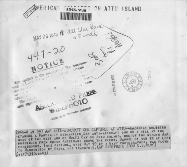
![Captured Japanese anti-aircraft gun, 29 May 1943. [U. S. Navy Photo]](index_htm_files/221148.jpg)
6a. Japanese anti-aircraft gun captured at Attu--American soldiers examine a
partially dismantled Japanese anti-aircraft gun on a hill at the head of the west
arm of Holtz Bay on Attu Island. Barrel of gun is at left foreground. This picture,
made May 19 by a Navy photographer, was flown to Washington by Naval Air
Transport. (AP Wirephoto from U. S. Navy). 29 May 1943. Front and Back. Nadine
Smith/George Smith, posted 26 Dec 2014. [George & Nadine Smith]
Click HERE for enlarged view
Click HERE for enlarged view
6b. Reverse side of photo.
