

The Aleutians

The Lands of 50 mph Fog
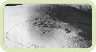
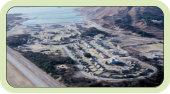
Adak
Adak was one of the most populated of the Aleutian Islands during WWII, which also became a major base for the U. S. Navy after WWII. The movie "Report from the Aleutians," a WWII Documentary directed by John Huston, shows fairly well the daily routine experienced by the GIs living on Adak at that time. The movie also includes a segment where you can view the war effort from a B-24 as you "ride along" on Kiska bombing runs (you can find this movie on our Bibliography page).Amchitka
Amchitka, so named by the Aleuts who've inhabited the Aleutian Islands for at least 9000 years, is one of the North Pacific Aleutian Chain's Rat Islands. It is located approximately 1340 miles west southwest from Anchorage, Alaska, and 870 miles east of Petropavlovsk, Kamchatka, of the Russian Far East. It is 35 miles long, and almost 3 miles wide. Early Russians referred to this island as Ostrov Amchitka. WWII saw significant activity on Amchitka as U. S. Forces moved west down the Aleutian chain to recover the islands of Attu and Kiska.Attu
Attu is the westernmost piece of American territory andthe largest island in the Aleutian Islands' "Near Islands" grouping. It is nearly 1,100 miles from the Alaskan mainland and 750 miles northeast of the northernmost of Russia's Kurile Islands, and 4,800 miles from Washington DC! Attu is about 20 by 35 miles in size,the highest elevation being 2,946'(Attu Mountain), and until 1 August 2010 was the home of a small number of U. S. Coastguard personnel operating a LORAN station. Attu was occupied on 6 June 1942 by the Japanese and was the site of some of the bloodiest fighting during WWII, second only to Iwo Jima. The battle for Attu began on 11 May 1943 and ended on 30 May 1943.Unalaska (Dutch Harbor)
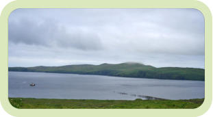
The island of Unalaska, part of the Fox Island grouping of islands along the Aleutian chain, consists of 111 square miles of land and 101 square miles of water. The highest elevation of 5,691 feet can be found on the island at the top of Makushin Volcano, which is not visible from the town of Unalaska. The Port of Dutch Harbor, which is part of the City of Unalaska, is located on Amaknak Island which is connected to Unalaska by a bridge. Unalaska’s population was 4,376 according to the 2010 U. S. Census. The population triples between August and May due to the arrival of commercial fisherman. Unalaska is approximately 792 miles by air south and west of AnchorageKiska
Kiska is an island in the Rat Islands group of the Aleutian Islands of Alaska. It is about 22 miles (35 km) long and varies in width from 1.5 to 6 miles (2.4 to 9.7 km). It is part of Aleutian Islands Wilderness and as such, special permissions are required to visit it. The island has no permanent population.Kodiak
Kodiak is the primary community located on Kodiak Island, Alaska. The 2020 census indicates a population of 5,581 citizens. Originally inhabited by the Alutiiq natives for over 7,000 years (some say 9,000 years!), the community was settled in the 18th century by subjects of the Russian crown and became the capital of Russian Alaska.Shemya
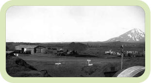
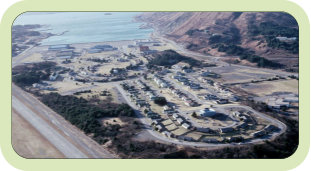
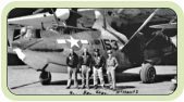
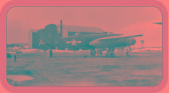
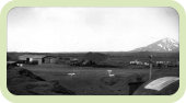
Until 1995, if you happened to be in the U. S. military, worked for the U.S. government, or were a DoD contractor, you could have won an all expense paid vacation to Shemya, Alaska. This would include round trip air fare, shelter, and three square meals a day thrown in for good measure. Shemya is located near the western end of the Aleutian chain, 1,259.2 nautical miles away from Anchorage, Alaska (see map). The island of Attu is 34.8 nautical miles NW from Shemya, while Agattu is just off to the west and can be seen from Shemya on a clear day. On March 31st, 1995, after 50 years of being a haven for U.S. military and military support personnel, Shemya was turned over to caretaker status to be operated by the DoD contractor firm PMC. The Island is now a strategic refueling stop for military aircraft as well as link in the United State's long-range early warning radar system.Umnak
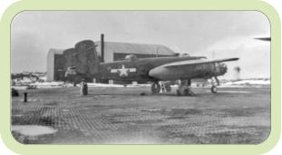
Umnak is part of the "Fox" islands grouping, southwest of mainland Alaska in the Aleutian chain. It is the third largest of the Aleutian islands, having a land mass of around 675 square miles. At this time in it's history, Umnak supported about 50 Aleut residents, about 15,000 sheep, and a heard of imported reindeer. Umnak has no natural harbor, supports no trees, and is very mountainous. There were serious doubts that a runway could in fact be constructed here. General Buckner solved the runway problem by importing to Umnak 3,000,000 square feet of Marsden Matting, perforated-steel plating (PSP) that could be assembled with other steel plates to create a flat surface upon which aircraft could take off and land. On March 31st, 1942 the 807th had completed the 3,000 by 100 foot runway on Umnak for use by Jack Chenault's P-40 fighter aircraftMisc. Remote Sites
On occasion we get also get nifty photos of other sites around Alaska. The lucky few to experience living on one of these miscellaneous sites share much in common with those in the Aleutians, most notably the isolation from the rest of humanity. This is the beginning of links to these sites as well.Murphy Dome is one such site. I learned about the Dome from Walt Pate, a former supervisor who was stationed there in 1963.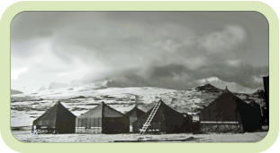
© HLSWILLIWAW.COM
Built with XARA
In 1996 I created the original Shemya website as part of an effort to learn how to build websites. As soon as I posted the Shemya
website, WWII veterans who managed to find their way to the site asked, wondered, requested additional pages to be
constructed using material they had accumulated from their tours of duty during and after WWII*. The second island, Attu,
evolved from that original beginning. The other islands soon followed, with individuals sharing their material with me which has
resulted in an interesting collection of stories, photos, and experiences. I thank all who’ve contributed over the past years to this
effort!
George Smith
Islands

Last Update: 6 Dec 2021
Current Update: 03/12/2022 09:46


The Aleutians

The Lands of 50 mph Fog
Adak
Adak was one of the most populated of the Aleutian Islands during WWII, which also became a major base for the U. S. Navy after WWII. The movie "Report from the Aleutians," a WWII Documentary directed by John Huston, shows fairly well the daily routine experienced by the GIs living on Adak at that time. The movie also includes a segment where you can view the war effort from a B-24 as you "ride along" on Kiska bombing runs (you can find this movie on our Bibliography page).Amchitka
Amchitka, so named by the Aleuts who've inhabited the Aleutian Islands for at least 9000 years, is one of the North Pacific Aleutian Chain's Rat Islands. It is located approximately 1340 miles west southwest from Anchorage, Alaska, and 870 miles east of Petropavlovsk, Kamchatka, of the Russian Far East. It is 35 miles long, and almost 3 miles wide. Early Russians referred to this island as Ostrov Amchitka. WWII saw significant activity on Amchitka as U. S. Forces moved west down the Aleutian chain to recover the islands of Attu and Kiska.Attu
Attu is the westernmost piece of American territory andthe largest island in the Aleutian Islands' "Near Islands" grouping. It is nearly 1,100 miles from the Alaskan mainland and 750 miles northeast of the northernmost of Russia's Kurile Islands, and 4,800 miles from Washington DC! Attu is about 20 by 35 miles in size,the highest elevation being 2,946'(Attu Mountain), and until 1 August 2010 was the home of a small number of U. S. Coastguard personnel operating a LORAN station. Attu was occupied on 6 June 1942 by the Japanese and was the site of some of the bloodiest fighting during WWII, second only to Iwo Jima. The battle for Attu began on 11 May 1943 and ended on 30 May 1943.Unalaska (Dutch
Harbor)
The island of Unalaska, part of the Fox Island grouping of islands along the Aleutian chain, consists of 111 square miles of land and 101 square miles of water. The highest elevation of 5,691 feet can be found on the island at the top of Makushin Volcano, which is not visible from the town of Unalaska. The Port of Dutch Harbor, which is part of the City of Unalaska, is located on Amaknak Island which is connected to Unalaska by a bridge. Unalaska’s population was 4,376 according to the 2010 U. S. Census. The population triples between August and May due to the arrival of commercial fisherman. Unalaska is approximately 792 miles by air south and west of AnchorageKiska
Kiska is an island in the Rat Islands group of the Aleutian Islands of Alaska. It is about 22 miles (35 km) long and varies in width from 1.5 to 6 miles (2.4 to 9.7 km). It is part of Aleutian Islands Wilderness and as such, special permissions are required to visit it. The island has no permanent population.Kodiak
Kodiak is the primary community located on Kodiak Island, Alaska. The 2020 census indicates a population of 5,581 citizens. Originally inhabited by the Alutiiq natives for over 7,000 years (some say 9,000 years!), the community was settled in the 18th century by subjects of the Russian crown and became the capital of Russian Alaska.Shemya
Until 1995, if you happened to be in the U. S. military, worked for the U.S. government, or were a DoD contractor, you could have won an all expense paid vacation to Shemya, Alaska. This would include round trip air fare, shelter, and three square meals a day thrown in for good measure. Shemya is located near the western end of the Aleutian chain, 1,259.2 nautical miles away from Anchorage, Alaska (see map). The island of Attu is 34.8 nautical miles NW from Shemya, while Agattu is just off to the west and can be seen from Shemya on a clear day. On March 31st, 1995, after 50 years of being a haven for U.S. military and military support personnel, Shemya was turned over to caretaker status to be operated by the DoD contractor firm PMC. The Island is now a strategic refueling stop for military aircraft as well as link in the United State's long- range early warning radar system.Umnak
Umnak is part of the "Fox" islands grouping, southwest of mainland Alaska in the Aleutian chain. It is the third largest of the Aleutian islands, having a land mass of around 675 square miles. At this time in it's history, Umnak supported about 50 Aleut residents, about 15,000 sheep, and a heard of imported reindeer. Umnak has no natural harbor, supports no trees, and is very mountainous. There were serious doubts that a runway could in fact be constructed here. General Buckner solved the runway problem by importing to Umnak 3,000,000 square feet of Marsden Matting, perforated-steel plating (PSP) that could be assembled with other steel plates to create a flat surface upon which aircraft could take off and land. On March 31st, 1942 the 807th had completed the 3,000 by 100 foot runway on Umnak for use by Jack Chenault's P-40 fighter aircraftMisc. Remote Sites
On occasion we get also get nifty photos of other sites around Alaska. The lucky few to experience living on one of these miscellaneous sites share much in common with those in the Aleutians, most notably the isolation from the rest of humanity. This is the beginning of links to these sites as well.Murphy Dome is one such site. I learned about the Dome from Walt Pate, a former supervisor who was stationed there in 1963.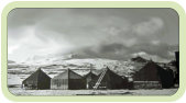


Current Update: 03/12/2022 09:46
© HLSWILLIWAW.COM
Built with XARA
Updated: 06/24/2022 09:41